

During my travels, I’ve been fortunate to see and experience much that is worth sharing.
My hope is that these images touch your hearts, much as the USA’s natural beauty has touched mine.
May the adventurous among you benefit from the travel information I share on these pages!
In the summer of 2014, I rendezvoused with my son at the Seattle airport, and we headed to Mount Rainier National Park. We spent the first three nights of our Washington trip at the Crystal Mountain resort, which operates one of its ski gondolas throughout the summer season to accommodate travelers such as ourselves. The morning after our arrival in Washington, we walked over to the Alpine Inn for an excellent breakfast, then headed into the park for about half a day.
I had gone over a map of the park long before the trip, and had even paid a “virtual visit” to Rainier via Google Earth, so I was already aware that none of the park’s highways have an all-encompassing view of the peak and the surrounding mountains, unlike other popular national parks such as Yosemite and Glacier. There are several places from which one can glimpse the top half of the peak... but if one is traveling in the park and wants a better view, it is necessary to park the car and hit the trail.
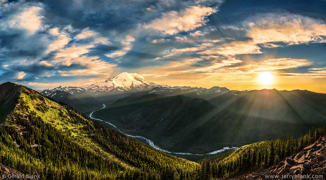
An excellent view of Mount Rainier from Crystal Mountain —
Click / tap image to view full size
The Crystal Mountain resort and ski area lies just outside the park boundaries, near the northeast entrance. Having learned that we could ride the gondola to the summit of Crystal Mountain, I chose that game plan. I don’t mind hiking for hours to capture an excellent view, but I’ll take a quicker way when opportunity knocks!
As we rode the gondola up to the Summit House Restaurant, I spotted the trail below us and pointed it out to my son. He agreed that riding up was more pleasant than climbing. We agreed that we would hike down after sunset, if the skies were clear enough; otherwise, we would ride the gondola back down.
We were pleasantly surprised that the Summit House is a real restaurant, as opposed to the cafeteria-style warming houses I had grown accustomed to in Montana. The prices are reasonable, and we agreed that the service and the food were both topnotch. We dined on the west deck, which has a fine view of the setting sun and Mount Rainier.
A squirrel appeared as we ate, hunting for crumbs on the deck. Some of the other guests attempted to capture a photo of the fuzzy creature as it darted between chair legs and the feet of the diners. My son had one eye on his plate and one on the squirrel. I had finished eating by that time, so the eye I wasn’t using to track the critter was fixed upon the setting sun. It looked to be a cloudy evening... but there is often a short window of time which begins just before sunset, when the sun peeks out just below the cloud deck and spreads its warm rays over the mountains for a few minutes, before disappearing for the night.
After dining, we gathered up my photo gear and hiked a short distance. The short window of time I just mentioned had just begun, and there was no time to search for a better vantage point. As I set up my camera, my son asked: “Do you still want to hike back down?” I shook my head. “Look at the cloud cover. Now is the time! In a few minutes there won’t be any point in sitting up here.” My son seemed happy to ride the gondola back down instead of hiking down the steep trail, but I was happy that he would have stuck by my side, regardless of my choice. That’s the kind of man he is.
I used up every minute of my “window of time” that evening, but it was enough to capture the high-resolution panorama shown above.
↑ RETURN TO MAIN MENU AT TOP OF PAGE ↑
As mentioned above, I visited Mount Rainier National Park with my son in 2014. On our last day together, we went to the Paradise visitor’s center early in the morning. Consulting a trail map, we decided to try hiking the popular Skyline Trail, by way of the uphill (left fork). We did not make much progress that morning; the first half mile was fine, but as soon as we got higher we found the trail covered by slushy wet snowpack, and had a tough time just keeping ourselves upright.
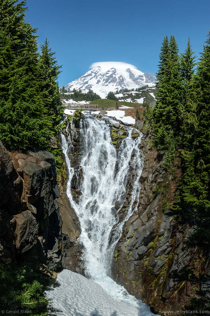
Myrtle Falls — Click / tap image to view full size
After lunch, we decided to try our luck on the right fork of Skyline Trail, which crosses Paradise Meadows and offers an excellent view of the Paradise River gorge and the Tatoosh Range located east of Rainier. The trail crosses Edith Creek, a tributary of the Paradise River, which plunges down the gorge. That spot is named Myrtle Falls, and is a popular spot for taking “selfies”. At the viewing area built by the Park Service, the waterfall is lined up perfectly with the peak of Rainier, so it seems to be example of good planning. But trees grow quickly in the Cascades, and by 2014 the ones at the viewpoint had gotten a bit overgrown. There was no longer a good clear view of the falls from the wooden guardrail.
I had my trustworthy traveling companion at my side, so I was not so easily daunted by a few spruce trees. I got myself down to ground level and squeezed through the trees and underbrush toward the gorge. My son helped me keep my balance by gripping my backpack—but I ventured out no farther than I could safely do with his help. I wanted our trip to have a happy ending! After capturing a few shots, my son gave my backpack a hard pull to help me get back up and behind the guardrail. Once I brushed the evergreen needles out of my hair, I mounted my camera to the tripod so my son and I could take an obligatory “selfie” for posterity.
I soon learned that Mount Rainier’s spring begins at the end of July, leaving only a month-long window for the wildflowers to wake up and do their thing. In fact, the summer season in the north coastal mountains is about as short as that of Glacier National Park. Rainier is a fairly large volcanic peak, and it collects enough winter snow to maintain a permanent glacial ice cap covering 36 square miles. Standing in the meadows below Paradise Glacier, the glacier seems as large as life. Even on the hottest summer days, hikers can never be sure when a downdraft of icy air will churn through the warmer air of the valley, sending a chill breeze down the slopes.
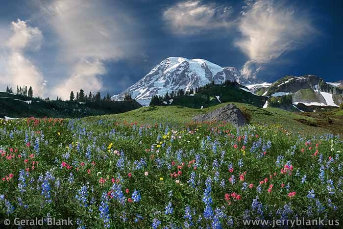
Paradise Meadows, below Paradise Glacier — Click / tap image to view full size
All the Pacific moisture packed on the peak of Rainier pretty much guarantees that every wildflower season, though it be short, will be a glorious display of Nature’s color.
I had an opportunity to make a solo hike on the Skyline Trail a little later on my Pacific Northwest trip, and saw a much better display of color at the lower elevation meadows once I passed Myrtle Falls and the Edith Creek bridge. As you can imagine, I gave both my legs and my camera a good workout at Paradise! That afternoon, there were few other hikers along the route, but all the ones I did pass seemed as enchanted by the place as I was. The noise of cars, trucks, and people gave way to the soft sound of cascading water echoing across the Paradise River valley.
A short way past the meadow pictured here, I saw that the trail made a bend at a grove of large spruce trees. And then I heard it: A single bird, whose song rang clearly above the hushed waterfall noises in the distance.
I had seen enough beauty already to risk “sensory overload” or an “out-of-body experience”— but nothing that dramatic happened. I do recall hearing the bird song and exclaiming “Oh...” softly, letting out my breath and closing my eyes for a moment. My eyes reopened, and I approached the spruce grove quietly, hoping to catch a glimpse of my miniscule musician, but he remained invisible in the treetops. The music from the bird seemed to be the song of Paradise, something we humans can imitate, but never quite match.
From that point onward, my experience of the place was much the same as what I described in “Springtime in August”. Besides my heightened awareness of ambient sound, the colors I was seeing seemed to have an added dimension of light and life. Or, perhaps, it only seemed so because of the angle of the sunlight.
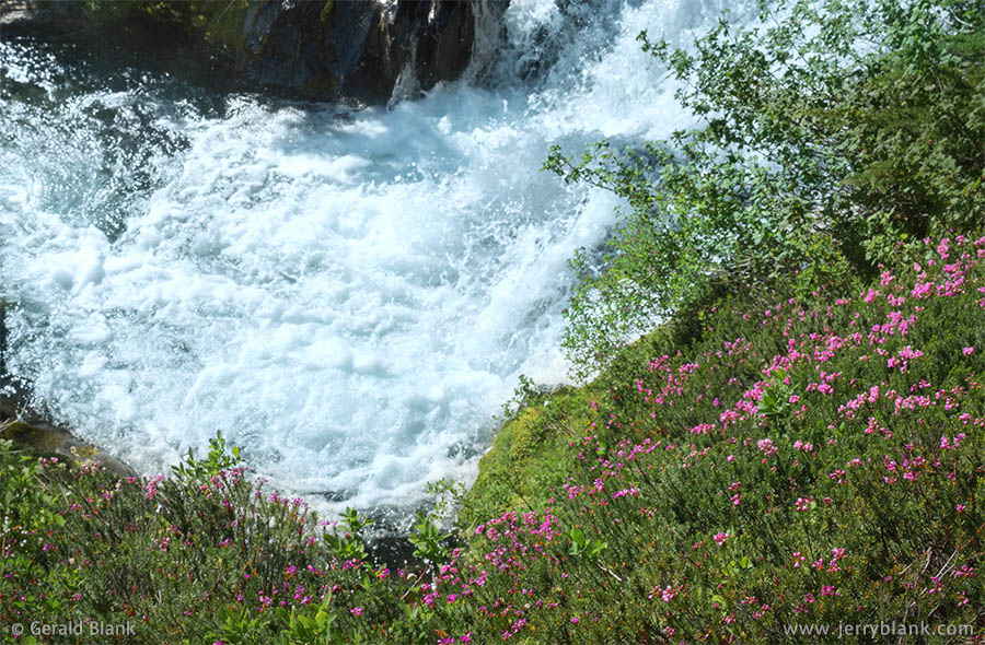
Pink mountain heather below the headwaters of the Paradise River.
Tap / click image above to view a video clip of the river and the meadows.
After a couple of hours I turned around and headed back, following the same route by which I had come. Coming near the spruce grove mentioned above for the second time, I was pleased and surprised to hear the bird song again; it is likely the music continued nonstop in my absence, and the invisible performer seemed unwilling to quit any time soon. Fortunately, I had sense enough to turn on my camera and switch it to “video” mode. Even though the lens recorded nothing but treetops, the microphone picked up a clear recording of the “Song of Paradise”, so I could weave it into the sound track of the video clip posted here.
Neither my photos nor my writing does justice to the beautiful places I have seen in the Pacific Northwest and other places in the USA. This video clip does better, perhaps, because I put more effort into creating it. If it inspires you to travel to Paradise and hear its song for yourself, that is good enough for me!
Before the Internet Age, when I was a young photographer, I would study magazine images created by masters such as Art Wolfe and Galen Rowell. At that time, my goal was to travel to faraway places, refine my skills, and get published—and to a small degree, I have succeeded. But with the advent of photo sharing websites, there are now millions of exceptional images at our fingertips, captured by millions of people—a very slim minority of whom are professionals.
Observing all this is at both rewarding and humbling. Humbling, because I now realize that many people create beautful art... and in a world of individual expression, there can be no “king of the hill”. But mostly rewarding, because my capacity to share my work is no more limited than anyone else’s. The best rewards are those moments—such as a morning at Clements Mountain in Glacier, or an afternoon at Paradise—when I pause on the trail, take everything in, and feel deeply grateful for being at that place for that moment.
↑ RETURN TO MAIN MENU AT TOP OF PAGE ↑
In the summer of 2014, my son and I traveled to the Pacific Northwest for the first time. We spent a few days together at Mount Rainier National Park before he returned home to Minnesota, while I continued exploring Washington and Oregon.
Paradise Glacier is only one of many on the Mount Rainier, and is the source of the Paradise River. Paradise Valley, and the meadows above it, are popular places for vacationers and photographers to visit — especially during the wildflower season, which usually begins late July and ends in late August.
Narada Falls — Click / tap image to view full size
We arrived at this amazing place in the middle of July, when the early season wildflowers such as beargrass began to appear on the slopes. In spite of the summer heat, much snow remained on the lower slopes of Rainier, and the waterfalls were all running strong. Our first visit to a waterfall took us to Narada Falls, the last waterfall on the Paradise River before it merges with the Nisqually River to the west.
I thought “Narada” an unusual name, and looked it up on Wikipedia after I returned home. It is Indian, but not Native American. Narada was a teacher described in the Vedas, apparently devoted to Vishnu; the person who named the waterfall obviously had an interest in Vedic lore.
The river gorge at Narada is narrow and V-shaped, as can be seen in the photo at right. Large chunks of rock beneath the lower falls have come loose and have tumbled forward into the riverbed, and the full weight of the falling Paradise River is brought to bear on this rockpile, which acts as a giant atomizer.
Until observing all that, I was surprised at the amount of water droplets and mist shooting over the opposite side of the gorge and onto the viewing area with its wooden guardrail.
Within seconds, we could hardly see through our eyeglasses. “If I take my lens cap off, the glass will be sprayed before I can get the shot”, I complained, hurrying through the shower of misted water. “The best photos I’ve seen of this waterfall are views looking up from the bottom of the gorge.”
My son was quick to agree and move onward; he was also getting wet. We made our way downhill, away from the waterfall, and eventually found a couple of massive slabs of rock alongside the river, which provided a convenient and safe view of the waterfall.
We spent enough time there to capture several still images, and also some 4K HD video footage which you can view here. We spent about a half hour at our vantage point, until a light breeze sprang up from the east, sending Narada’s mist in our direction. By then we were getting chilled, despite the 80-plus temperatures at the trailhead. In narrow gorges such as this one, Nature’s air conditioning is often cranked to the max.
I stowed my camera gear back into my pack, and we returned to the trailhead along the same route we came down. Immediately after we got through the cloud of mist facing the waterfall, the warm summer air hit us quickly; it felt as if we’d stepped out of a refrigerator.
There are few wildflowers in the “air conditioned” portion of the trail, since most wildflowers like to grow in bright light, but there were shrubs of brightly-colored small roses nearby. Checking online after I returned home, I discovered that these are probably Little Woods roses. They seem to grow well near waterfalls during the summer, bathed as they are with mist 24/7.
July is a good month for a photographer to visit Narada Falls, but when the water volume decreases in August and the high meadows are in full bloom, the viewing area facing the top of the waterfall is a great angle too — and visitors are less likely to be showered by Paradise River water. If the sun is shining on the bottom of the falls, a rainbow will likely be hovering in the mist. Some photographers like to visit in January, when the head of the gorge resembles a giant ice castle.
↑ RETURN TO MAIN MENU AT TOP OF PAGE ↑
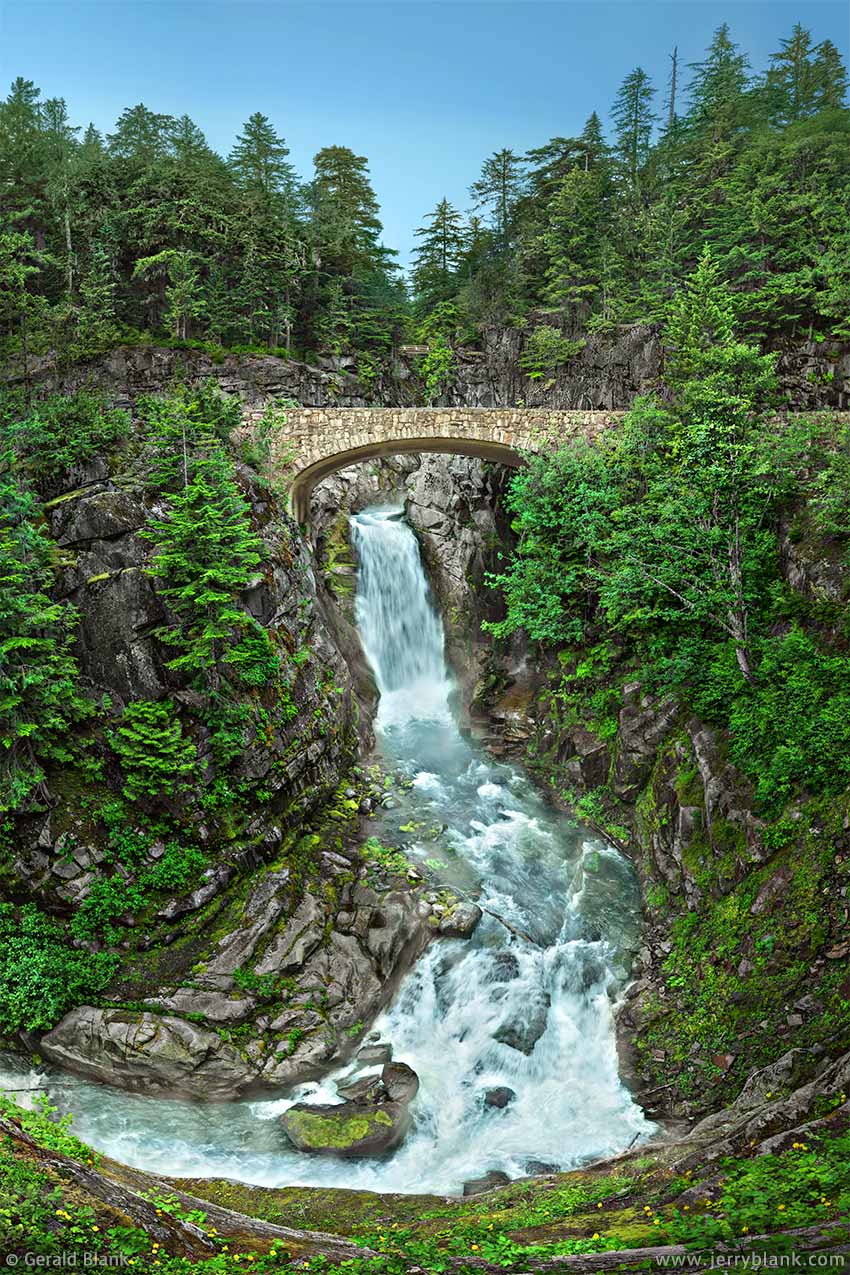
Bridge over Christine Falls — Click / tap image to view full size
As I discovered in July 2014, Mount Rainier National Park has plenty of waterfalls, due to its geography and weather; it receives over 120 inches of precipitation per year! Many of these waterfalls can be easily accessed via hiking trails. A few of the really fine waterfalls practically have drive-up access, which is nice for those who are young in spirit but have elderly legs. One such waterfall is Narada Falls, which I featured in an older post shortly after returning from Washington.
This post features Christine Falls, which is located between the Nisqually Gorge and Narada Falls in the southwest corner of the park. Christine Falls lies on Van Trump Creek, and does not have as high a flow rate as Narada Falls, but as can be seen in the photo at right, it is no less picturesque. Both waterfalls have an upper and lower section, divided by highway bridges faced with natural stone masonry.
My son and I visited the waterfall once during our travels in July. My intent was to take a still photo such as this one, and also to capture some HD video footage. July and August, however, are the park’s busiest months. I found it impossible to get a clear shot of the bridge, due to all the cars and trucks crossing it... the moving vehicles were playing hell with the “idyllic woodland view” I was trying to capture.
A few days later, I had to drop my son off so he could catch his flight home. On the return drive from Seattle, I could see that sunset would happen less than an hour after I returned to Mount Rainier, and realized I could probably get much better video footage of Christine Falls at that time; there would still be enough skylight, and other visitors would be few and far between.
After parking off the road east of the bridge and returning to the Christine Falls observation point, I was pleased to discover that things played out just as I expected. I could capture much better audio and video at that hour — and more importantly, I felt more refreshed and relaxed.
The few other photographers that did arrive were in good spirits also, and no one got in each other’s way. That is something worth considering if you intend to visit the highways and trails at Mount Rainier National Park someday. If one wants to see wildlife and hear the sounds of the mountain, rather than throngs of tourists, I highly recommend devoting the early morning and late evening hours to exploration, and use the midday hours for R&R. Keep in mind that you will need to dress in layers, even if rain is not in the forecast, because Rainier is covered with 36 square miles of solid ice. Even in the heat of summer, you may round a bend in the trail and suddenly feel as though you walked in to (or out of) the Arctic.
The Comet Falls trailhead is only a quarter mile west of Christine Falls, and is defintely worth checking out. Those with keen eyes may be able to see a wooden footbridge crossing Christine Falls in the photo above. toward the top. That bridge is part of the Comet Falls trail, so those hiking that trail will enjoy several views of great waterfalls on Van Trump Creek before the trail ends at the junction of the Van Trump and Mildred Point trails, farther up the mountain.
↑ RETURN TO MAIN MENU AT TOP OF PAGE ↑
In my 2014 summer travels, one of the places I was fortunate enough to visit is the Mount Baker Scenic Byway, which is located in Washington just south of the Boundary Mountains on the border of British Columbia. The Byway, which is part of WA State Hwy. 542, can be accessed from the west via Interstate 5. It takes about an hour to travel from the interstate to the Glacier visitor center. From there, the Byway winds eastward through the upper Nooksack River valley. Eventually, the route turns more southward, and runs past Picture Lake to Artist Point. As their names imply, these scenic spots have inspired many an artist and photographer to travel the Scenic Byway for great views of Mount Baker, the northernmost volcano of the Cascade Range, and Mount Shuksan, which is craggier and bears no resemblance to its neighbor to the south.
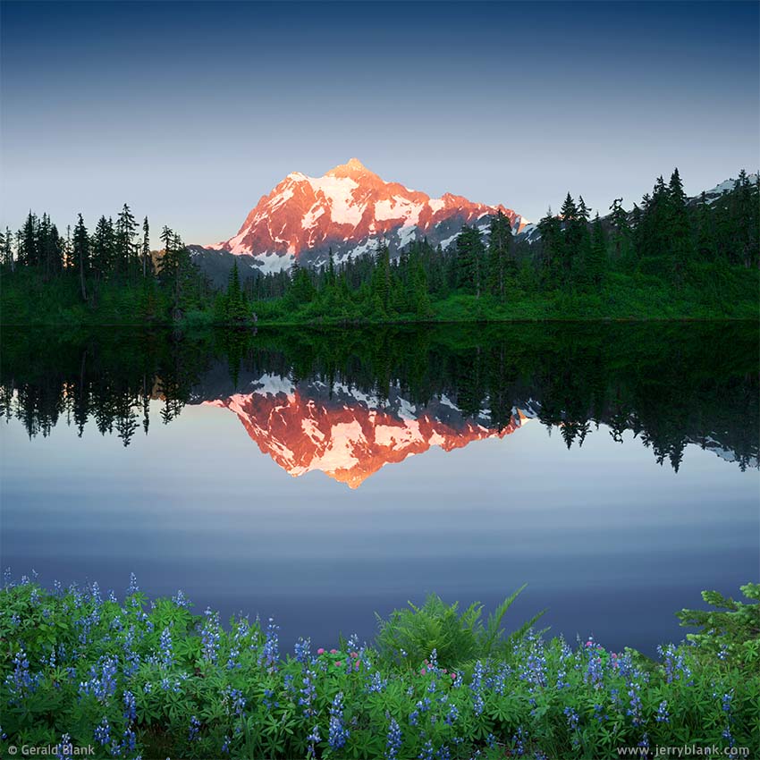
Sunset at Mount Shuksan, Washington — Click / tap image to view full size
By August, summer hikers can hike any number of trails leading from Artist Point or Picture Lake through places such as Heather Meadows, to discover great views of Mount Baker and Mount Shuksan. If the snows recede early, one can enjoy summer scenery as early as July.
In 2014, toward the end of July, I checked into the Inn at Mount Baker about midday, and headed eagerly up the valley. The snowy season had persisted longer that year, which made for nice waterfalls, but the meadow trails leading to Mount Baker were still covered with snow. Though I saw no flowers in Heather Meadows on that trip, I did discover wonderful views of Mount Shuksan from the loop road. Artist Point is also a great vantage point from which to view the Boundary Mountains to the north.
I had already consulted the Internet about when the sun would set on that clear evening in northwest Washington, so I followed the Byway back down from Artist Point to Picture Lake and Highwood Lake. The west shores of both lakes offer great sunset views of Mount Shuksan, and—if the air is calm—a beautiful reflection as well.
I parked near Highwood Lake, and was a bit surprised that there were not mobs of other photographers around the lake, lined up elbow-to-elbow to get a clear view of the sunset alpenglow on the peak of Shuksan. But I was soon wondering whether I ought to hang around myself, because the wind was stirring the surface of the lake—not much, but enough to ruin the “mirror reflection” effect I’d hoped to see. The breeze persisted as the orange-gold glow of the setting sun appeared on the mountainside, then began to retreat upward, giving way to the shadow of the mountains behind me. Another photographer parked close by, in the meantime, and began taking photos of the glowing peak facing us.
When the bright orange glow disappeared from all but the highest peak of Mount Shuksan, it was replaced with a deep magenta-red color, caused by the surface air between the disappearing sun and the peak. Miraculously, the breeze went away in the same moment, and I began shooting, capturing images as long as I possibly could—which was only a minute, if that. But it was enough. The other photographer and I congratulated each other, then parted ways as twilight fell over the mountains.
I returned to the bed and breakfast I’d checked into earlier that day. The accommodations were splendid, with huge picture windows facing Mount Baker and the Nooksack River Valley. I thought how great it would be if I could get a bit higher up the foothills of the Boundary Mountains, so I could capture more of the river in the scene. I expressed my wish to Charlene, my friendly innkeeper, asking her if there was any possibility of hiking uphill from the Inn. She said there wasn’t a trail, but that I could try hiking up a logging road that can be accessed from the highway, about a mile to the east.
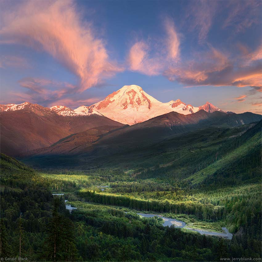
Mount Baker and the Nooksack River — Click / tap image to view full size
The following day, I was in no rush to leave; Charlene served up an excellent breakfast to me and to the four other guests staying at the Inn. I knew what kind of image I hoped to capture already, and that it would have to be done in the last half-hour of daylight. But I did take the time to find the logging road. The gate at the highway was open, and in a couple of minutes I was able to drive to a perfect vantage point.
When I’m not on photo safari, I deal with city traffic almost daily, and am in the habit of starting for my destination 15 minutes earlier than necessary in case of unexpected traffic problems. I had, however, gotten a bit complacent in the Nooksack River valley, and in the evening I was late getting to the logging road. There I found an unexpected traffic problem: The gate was now locked, which meant I would have to park my SUV at the gate and hike to the spot I’d picked out earlier.
I don’t think I’ve hiked up a hill as fast and as urgently as I did that evening, either before or since that trip! I prayed I’d have time enough to get the shot by the time I arrived, knowing that rainy weather would move in the following day and hang around for a while. If I missed my Mount Baker sunset that evening, I would get no second try on that year’s trip.
Divine Providence was gracious to me that evening, though, and I arrived at the chosen spot, with burning lungs and leg muscles, and with a couple of minutes to spare. I couldn’t see every bend of the Nooksack River from there, but enough of it was visible to make the composition work. When the sun was higher, the light on the mountain and the sky beyond was relatively flat, but I liked how it played over the treetops in the valley below my chosen hilltop. Finally, as the sun dropped closer to the Pacific, miles away to the west, the atmospheric haze did its thing, bathing Mount Baker and the eastern horizon in a warm red glow.
The show was over in a few more minutes. Satisfied, I packed my gear and headed back down the logging road. This time, however, I kept my pace slow, wanting to take in all the sights and sounds of that cool evening in the mountains of northern Washington... it kind of made up for the unnecessary anxiety I’d put myself through not long before.
Sadly, The Inn at Mount Baker closed years ago. However, the Mount Baker Ski Area opened for business after my 2014 trip, which has made this corner of Washington more popular. I expect that the Mount Baker Scenic Byway—with its network of spur roads and Forest Service trails—will be a special place for visitors to Washington state for many years to come.
↑ RETURN TO MAIN MENU AT TOP OF PAGE ↑
During my 2014 visit to the Pacific Northwest, I knew I would have to save at least a few days to visit the Columbia River Gorge National Scenic Area. Some of the country’s most picturesque waterfalls are located near the Columbia River, on the Oregon side.
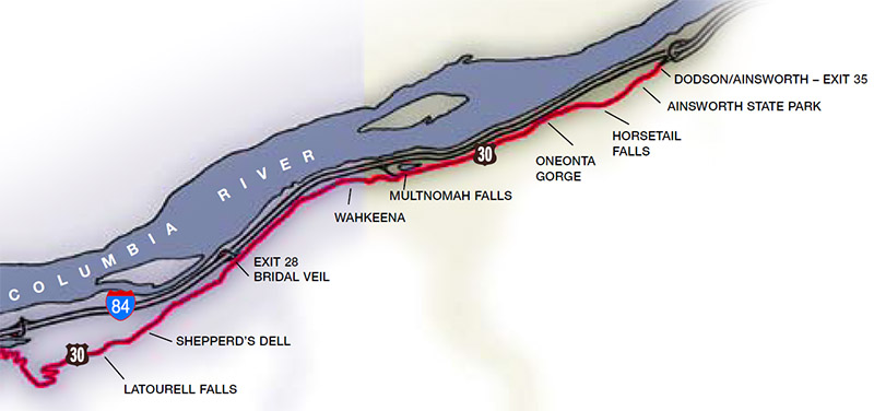
Waterfall hiking areas along the Columbia River Highway, just south of Interstate 84
The area displayed in the map shown here is perhaps a half hour’s drive east of Portland on Interstate 84, depending upon which exit you choose. Multnomah Falls, roughly in the center of the map, is by far the most visited of the Columbia Gorge waterfalls. If you look up “Multnomah Falls” on Google Images, you’ll quickly see why. Besides being photogenic, the hike to the Multnomah viewpoint is relatively short.
If you want to hike the Columbia River Gorge trails, I recommend checking this website first to get the latest trail information.
In 2014, I explored the waterfalls in Oneonta Gorge on the south side of Highway 30. Officially, there are four waterfalls along Oneonta Gorge Trail #424; the best one is Triple Falls, which is an easy-to-moderate hike for young-at-heart guys like myself. There’s a bridge that spans the creek above the falls, which is a nice touch for a waterfall scene. However, the falls themselves are definitely the main attraction.
Those wanting to see Columbia River Gorge waterfalls at their greenest should probably visit them in May and June, when water flow volumes are higher. Unless the midsummer season is wet, the green moss one expects to find dries out and becomes yellow or brown. I learned this firsthand, since my visit was late in July.
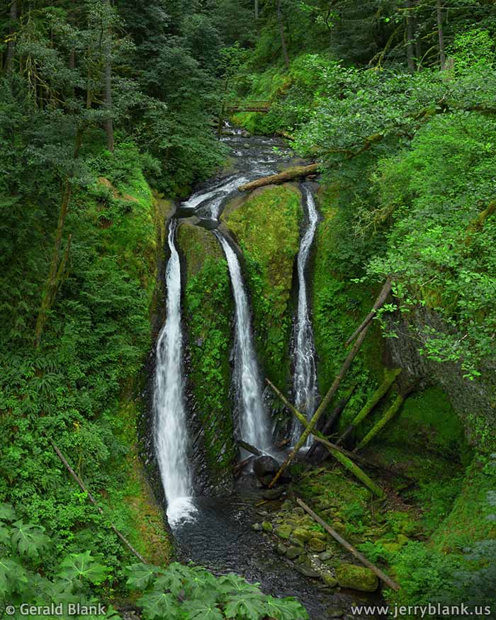
Triple Falls as it looked in 2014, on the Oneonta Gorge trail — Click / tap image to view full size
Luckily, it was not hard to turn back the calendar a month by playing with the hue/saturation settings in my computer. That fixed the color of the moss, but didn’t create more water in the image. I had to work with the water that was there to begin with. While editing this photo, I added brightness to the water to make it stand out, while darkening the surrounding foliage to exaggerate the effect and to draw the viewer’s attention to the waterfall.
Following a period of drought on the West Coast, the dense foliage in the region dried out, enabling the Eagle Creek fire to scour Oneonta Gorge in 2017.
By now, new and different types of vegetation have become established, and the view in this photo is probably very much altered. There will be more wildflowers and berry bushes for a few decades, until new tree growth begins to shade the gorge once again. The beauty of Nature is eternal, but ever-changing. We can capture beautiful images and video at this location for the rest of our lives, but this snapshot of time from July 2014 will never have a “Take 2”!
The rock formation over which the water drops has an interesting diagonal pattern, which will be more visible in the early 2020s if the bottom of this pool is not still clogged with fallen trees. I would have liked to get to the bottom of the gorge for a closer view; in fact, a few adventurous souls have done just that, and returned with nice low-angle pictures of Triple Falls. The alteration of Oneonta Gorge by mudslides may make access to the bottom easier, but in 2014 the gorge was steep and slippery. I didn’t attempt it. I’m a casual hiker, not a rock climber!
There were perhaps a dozen hikers between the overlook from which I shot this picture and the footbridge in the background. The trail on either end of the bridge allows easy access to the creek—so easy, in fact, that many of us explored the rocky creek bed under the big mossy log on the right side of the creek, as well as the pools just to the left of the log. It was actually great fun, but at the height of the spring runoff, poking around the water might not have been as safe. A creek surging over its banks is a wonderful thing to watch... but only from a distance. Something to keep in mind if you have kids with you. While raising my family, my kids were more agile than I was—and I usually slipped into the drink once per vacation. That’s one way to teach your kids caution, but I can’t recommend it!
In autumn, warm red and yellow colors begin to appear in the green foliage, and some of the trails in the Columbia Gorge look especially nice. Regardless of the season, though, I recommend hiking the waterfall trails when the sky is overcast—or perhaps near dawn or dusk—because patchy sunlight usually causes headaches for photographers using tripods and slow shutter speeds.
↑ RETURN TO MAIN MENU AT TOP OF PAGE ↑
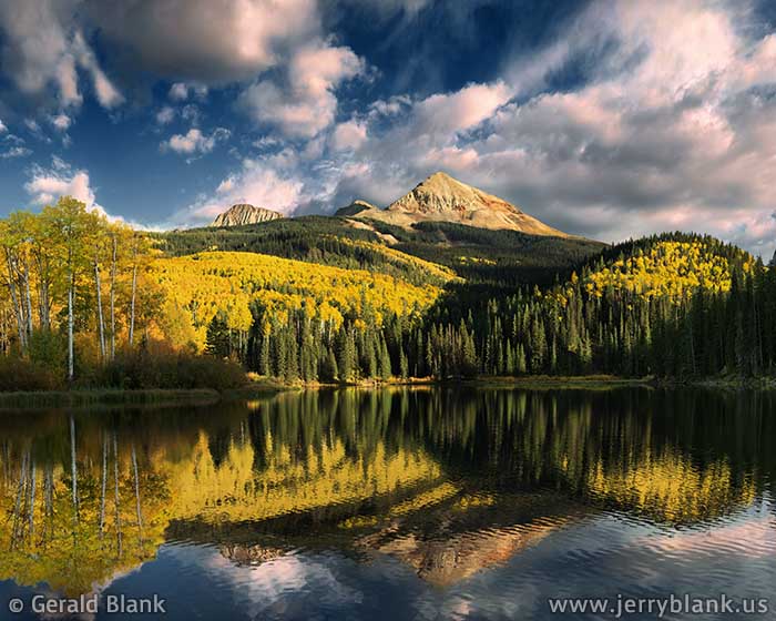
The Ophir Needles, pictured below, are a familiar landmark to the folks living in Colorado’s San Miguel County. They’re not marked by any signs as one drives south from Telluride on Colorado Hwy. 145, but there are Forest Service access roads to the Alta Lakes, which are small, high altitude lakes just north of the Ophir Needles. There are some great south views to the Needles from those lakes. If you are interested in exploring the area, I recommend downloading the Forest Service map here. The Ophir Needles can be found on the map just east of the Lizard Head Wilderness, southwest of Telluride.
In my two previous posts (below), I wrote about the old log cabin and the waterfall I discovered near Ames, which is located southwest of the Needles. To get to Ames, one must turn west on USFS Road 63L; the intersection is shown here on Google Maps.
In early October, you’ll find great autumn scenery along that road, looking west toward the Ames Cliffs. However, I found the Ames Cliffs to be less photogenic than the Ophir Needles, with their warm-colored rock and alternating stands of spruce and golden aspen trees.
Autumn aspens below the Ophir Needles in Colorado —
Click / tap image to view full size
As I explored Road 63L, I kept an eye out for a better vantage point of the Needles. Looking south across the Howard Fork canyon through the trees, I could see what looked like an access road on the far side. So I made my way back to the crossing at CO 145, hoping I would find luck along the new road I’d discovered.
From the crossing, where the Howard Fork flows westward beneath Hwy. 145, I drove slowly uphill as the highway curved to the southwest. At .17 of a mile, I saw an access road to the right. It was gated, but I found the gate open. Certain I was on the right track, I turned off the highway and began exploring the route. There is a fork in the road 0.2 miles in, but the right fork was gated, so I kept to the left.
I should mention that this access road was not shown on most maps, at the time I explored the route in 2014. I don’t know if it is still used by mine tailing reclamation workers, so you may find the first gate locked. If that’s the case, there’s no harm in parking on either side of the gate and walking the rest of the way.
Only about a half mile beyond the fork, I was rewarded with the sight pictured here. I wanted to shoot from where I was parked, but saw that if I wanted a closer look at the golden aspen trees, I’d have to pick my way carefully below the road—a steep slope covered with large chunks of talus. You can see the talus in the lower right corner of this photo.
After climbing down, I plunked myself down on the flattest chunk of rock I could find. Looking around, I noticed a flat, grassy meadow between the talus and the trees alongside the Howard Fork. I recognized this as one of the places in the San Juan Mountains where mining companies have piled the tailings from old mines, then topped the pile with soil and native grasses to reclaim the Colorado landscape. Since the grassy areas are level and flat, water running down from the mountains is more likely to percolate slowly through the sod and the tailings—instead of washing heavy metals out of the tailings and into the mountain streams below.
The gate I had just passed, I realized, led to the access road used by the heavy machinery operators doing the reclaiming work. I must give credit to the reclamation efforts, because after 7 years, I noticed that the streams in the San Juan Mountains run clearer than they formerly did.
Having recovered from my scramble, I started taking my photos of the autumn scenery that surrounded me. You can learn more about the great fall photo ops around Ophir and Ames by reading this post.
↑ RETURN TO MAIN MENU AT TOP OF PAGE ↑
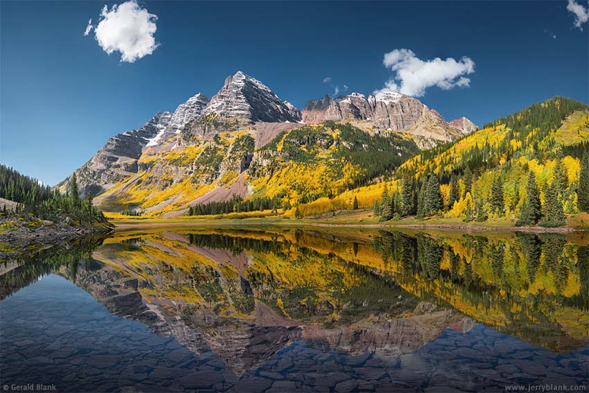
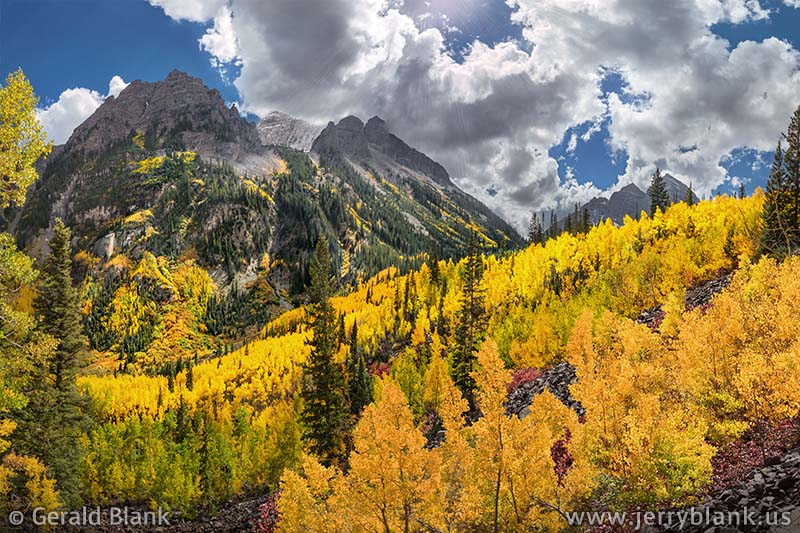
I began my 2014 autumn trip to the Colorado Rockies by making a beeline for Aspen, just as soon as I could get out of the Denver airport. The ski season craziness was still a couple of months away, but there were still many travelers in town, for the same reason I had come: To see some of the finest autumn scenery in the Rockies. The Maroon-Snowmass National Wilderness Area lies just south and west of town, and the Maroon Bells attract photographers year-round.
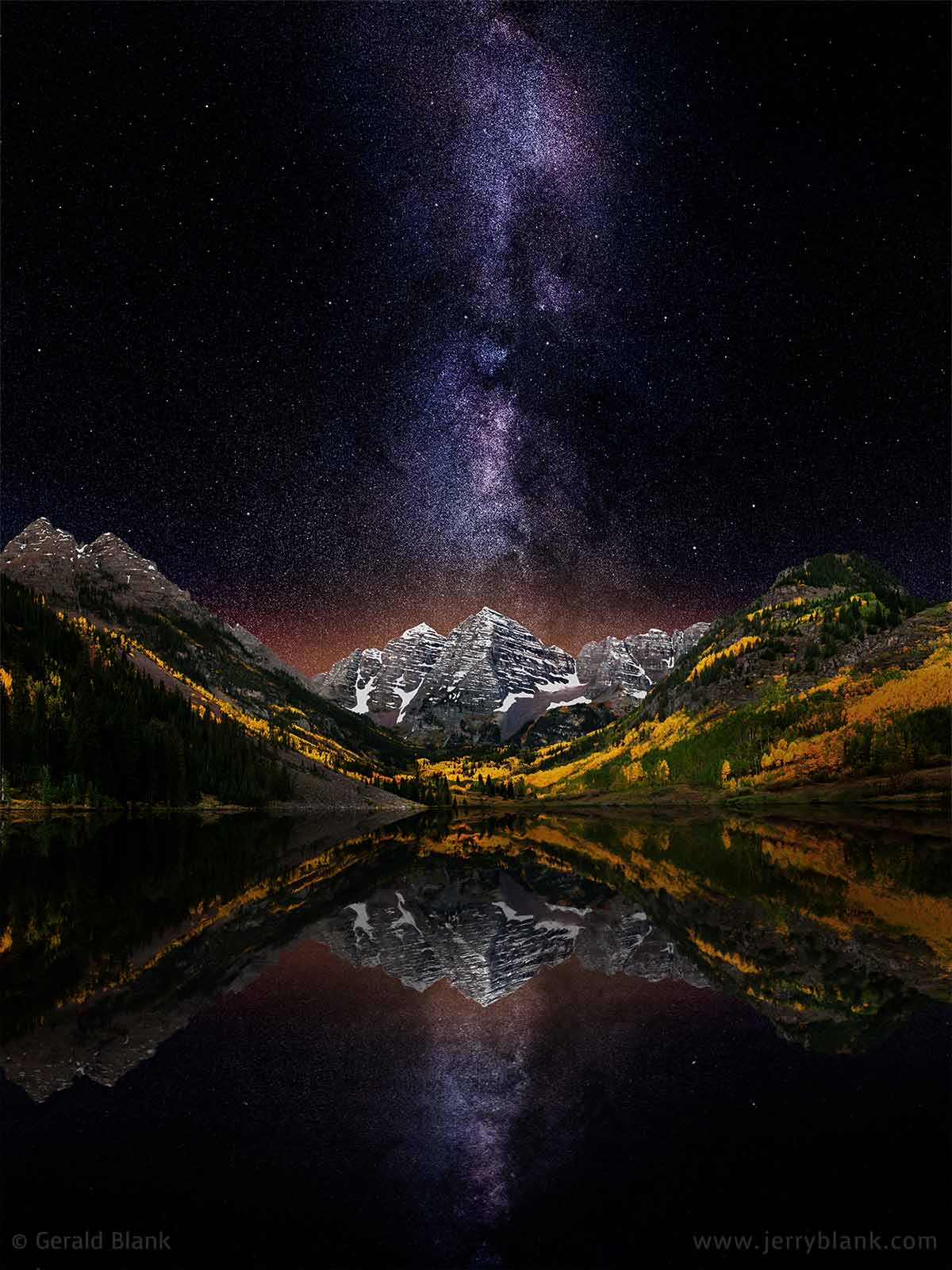
Autumn starscape at the Maroon Bells — Click / tap image to view full size
If one’s aim is to capture decent images, it helps to plan around weather conditions. On this occasion, I was granted clear skies for one night, persisting till the middle of the next day... so that night was spent near the shore of Maroon Lake instead at my lodgings in Aspen. I figured I’d have plenty of time to sleep in the hotel, once it started raining!
Later, in the very early morning hours, mountain climbers began arriving and hitting the trail southwest toward Crater Lake. I asked them why they chose to start their hike in the dark, and they replied that their destination was Maroon Peak—and that they needed to be off the mountain before the impending cold front arrived in the afternoon.
This area is photographed millions of times every year, at every time of the day, so I admire any picture of the place that stands out as unique. I wanted to capture something unique too. But that entails much more than taking as many pictures as possible.
For openers, there is almost always a breeze strong enough to cause rippling in mountain lakes. Too much causes the lake surface to lose its glassy “mirror” quality. Usually, I shoot at a low angle, as close to the water as possible, like the other photographers I saw that night. But you don’t have to shoot that close to get the picture. At Maroon, one can hike away from the lake and partway up the ridge of Sievers Mountain South. At that distance, of course, one must zoom in more, but any minor rippling on the lake surface will be less apparent.
As with most things, one has to find a balance. As one hikes up Sievers Mountain South, the image reflected in the lake begins to shrink. If one ventures too far uphill, the reflected mountains will disappear almost entirely, and one will only see stars in the reflected image.
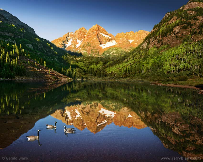
The Maroon Bells, in summer — Click / tap image to view full size
Maroon Lake’s location is ideal that way... there are many angles from which one can shoot. Many mountain lakes are at the bottom of steep gorges—and unless you’re equipped with a drone, you may find no more than one or two spots from which you can get a clear view.
I was satisfied with the images I captured that night, except for the appearance of the Milky Way, which ended up pretty much black and white regardless of the exposure time on Panasonic camera I was using at the time, which had an image sensor covering only 25 percent of a 35mm frame. Under moonlight or starlight, our eyes can’t see in color as well as our digital cameras can—and most consumer cameras record starlight in monochrome also. Nonetheless, I have seen nicely colored Milky Ways in many online photos.
I aim to be realistic with my scenic photos. I don’t want folks to be disappointed by going to a place I’ve been, only to find that it looks blander on location than my published images! This image is a rare exception: I was trying to create something more “artsy”. I trust viewers will forgive me for Photoshopping this night image to mimic the colors a late-model astrophotography camera might have captured.
The second photo in this post was captured just after sunrise, during my previous visit in the summer of 2012. While the aspen foliage is less showy during the summer season, the warm morning sunlight lights up the peaks in a way that I find appealing. That’s the long way of saying most of the images we capture aren’t “better” or “worse” than anyone else’s; they’re just unique. I believe the same holds true of the subject matter. It may be hard for me to discover beauty in the desert, but my brother Mike and many other photographers do just that on a regular basis, and they do it well.
Getting back to that September night in 2014: As the stars faded away, the red rays of the rising sun struck the top of Maroon Peak, which was a beautiful sight to me—and to all the others who had arrived to watch and take pictures. After watching the sunrise, I hit the trail leading to the Bells, intending to get to Crater Lake, about 2 miles in, before the weather moved in. You can see how that hike turned out by reading the next entry...
↑ RETURN TO MAIN MENU AT TOP OF PAGE ↑
I had visited Aspen, Colorado and the nearby Maroon-Snowmass Wilderness Area on a couple of previous occasions. In 2012, I captured a nice early morning image of the Maroon Bells, and decided to follow the trail into the wilderness area to Crater Lake, which lies much closer to the peaks. In fact, I was pleased to see that the Bells were practically in my face at that location. (See a detailed Maroon Bells and Crater Lake trail guide here.)
Unfortunately, the summer of 2012 had started out dry, and Crater Lake was not much more than a pond when I arrived there. But I did notice many aspens growing on the lower slopes of Maroon Peak, starting perhaps a quarter mile from the lake and continuing right down to the shoreline. So I did what I often do in such cases: I took several photos from various angles. Even if I know the light and the timing are bad, at the very least I want to have “reference” images to help plan a future trip.
Maroon Peak reflected in Crater Lake — Click / tap image to view full size
It was late in July at the time, and there are great wildflower-filled meadows only another mile uphill from Crater Lake. But summer storm clouds were quickly gathering around the Bells, and I knew I’d probably find lightning, not sunshine, by the time I reached that altitude... so I called it a day and headed north to Snowmass for the night.
In 2014, I arrived in Aspen in time for the peak autumn color coveted by so many folks like myself. I rolled into town via Independence Pass late on September 19, and made up my mind to get to the Maroon trailhead early the following morning. Most autumn tourists and photographers take photos of the mountains from the shore of Maroon Lake, which is a great angle if the wind is calm enough to get a nice reflection of the Bells in the water.
I spent much of the night by Maroon Lake, capturing night sky photos of the Bells reflected in the lake (See previous blog entry). By about 3 am, another photographer arrived. By 6:00, when the light from the pre-dawn sky was bright enough to see the surrounding canyon, the photographers along the shore of Maroon Lake were nearly elbow-to-elbow.
I stayed by Maroon Lake until the scarlet light from the rising sun hit the peaks of the Bells. After that, I decided to head up to Crater Lake, instead of hanging around Maroon Lake until late morning. Based upon what I had seen in my old 2012 photos, I knew I wanted to arrive at Crater Lake no later than mid-morning.
I felt no need to rush up the trail, though. I used to start my day trips early, to spare myself anxiety if the trip is delayed. Now I’m a little older and wiser, enough so to know that I will arrive at the right place at the right time (in spite of myself). On that day, the only delays occurred when I paused on the trail to take in the sights and sounds surrounding me.
A quarter mile from the lake, the trail turns southward and I could see the scenic aspen grove I mentioned above, now dressed up in bright gold leaves... a much grander sight than the green leaves I had seen the first week of August 2012. My pace quickened as I covered the last stretch of trail to Crater Lake, and the view from the shoreline was more colorful and more beautiful than I’d dared to hope for. Writing this last paragraph, I’m reminded that we already know in our heart what’s possible in our lives, but we only hear what’s within if we make an effort to quiet the louder thoughts coming from our brain!
↑ RETURN TO MAIN MENU AT TOP OF PAGE ↑
This blog entry sort of wraps up my brief adventures in Colorado’s Maroon-Snowmass National Wilderness, which began, as I wrote above, one September night, shooting the Maroon Bells reflected in Maroon Lake. I stayed at Maroon Lake until shortly after sunup, then hit the Crater Lake trail, a great hike I wrote about in the preceding blog entry.
Most of Maroon Lake lies within the White River National Forest, but soon after departing from the trailhead, one crosses the boundary into the wilderness area. One can’t see much of the Maroon Lake valley during the first leg of the hike, because the trail is hemmed in closely by the mixed spruce and aspen forest.
Finally, the trail opens up at a fairly large slide area, which is pictured at right. At some point in the past, a portion of Sievers Mountain’s south ridge broke up and sent a cascade of talus all the way down to West Maroon Creek. The rockslide can easily be seen here on Google Maps.
The fiery colors below Pyramid Peak — Click / tap image to view full size
If you follow the link, you’ll easily be able to see where the trail crosses the rockslide, a bit below the spot from which I took this photo. The slide is no longer just a big heap of loose rock; as can be seen in the photo, there are still unstable portions covered with talus. The majority of the slide has been stabilized by the new aspen groves which have established themselves.
I paused at this spot early in the morning, on the way to Crater Lake. The view was okay, but the sun was nearly behind me—not flattering to autumn foliage. I took a few pictures, then returned to the trail. I was glad to have my hiking poles by then, because the trail gets rough where it crosses the talus, and pretty much stays that way almost all the way up to Crater Lake.
After capturing my image of Crater Lake, I took my time heading back down the rocky trail. There are better views on the higher section, and I stopped often during the afternoon to take in the scenery and capture a few more images of the amazing autumn color.
Upon returning to the rockslide area I described above, I looked back toward Pyramid Peak. The sun had crossed west of the peak by then, and was now back-lighting a billion lemon, lime, and orange-colored aspen leaves. The picture above can give you but a taste of the golden glow that surrounded the trail at that point. The trail was now jammed with other landscape photographers, all with cameras pointed at Pyramid Peak, so I scrambled a short way off-trail over the treacherously-loose talus, which kept me out of other folks’ way—and allowed me to keep them out of my field of view.
Finally, I decided if I hadn’t gotten my fall scenery pictures by then, I never would. So, with a grunt, I hoisted myself off my rocky seat with the aid of my hiking poles, and picked my way back to the trail. The last leg of the return hike, with its smoother trail, was a welcome change from the rock-strewn route higher up. “Leave the talus for the marmots and the mountain goats this evening”, I thought. “They seem to like it just fine”.
↑ RETURN TO MAIN MENU AT TOP OF PAGE ↑
The third week of September 2014 turned out to be an excellent time for me to explore the fall scenery around Ridgway, Colorado. Generally, those seeking autumn color will find plenty of it, if they arrive in Colorado anywhere in between the last week of September and the first week of October.
I began by driving west out of Ridgway on CO Highway 62. Normally, the view south to the Sneffels Range from CO 62 is awash in fall color by the end of September, but the timing can vary widely from year to year—and during this particular September, its aspen foliage was still emerald green, except for bits of yellow in the higher elevations.
Therefore, I went to plan “B” and decided to check out Telluride and the San Miguel Range, just south of the Sneffels Range, which simply meant staying on CO 62 and heading southwest. With my orignal plans out of sight and out of mind, my eyes were fixed on the road ahead, ready to catch a new splash of warm color at each bend or hilltop.
Within a half hour of leaving Ridgway, I crossed over Dallas Divide and into San Miguel County. Only a mile from the county line, I was stopped in my tracks, so to speak, by something I hadn’t seen before: A small aspen grove on a hillside, with its leaves glowing in a perfect tangerine hue as they fluttered in the breeze. The picture below can be viewed in full-window mode if you click on to it, but even the larger view can only give you an idea of the orange light that was bombarding my eyeballs.
An aspen grove that will stop you in your tracks — Click / tap image to view full size
This hillside happens to be the southeast corner of the Howard Flats, a small wooded area on the north side of Hwy. 62. To my amazement, I spotted another colorful aspen grove in the distance, almost out of sight. What was amazing was that grove’s leaf color: Not gold or even orange, but red. Normally, one sees only isolated clumps of aspen foliage in orange and red. That day was the first time I had seen aspen groves of one solid color (except for the usual green or yellow).
It was midafternoon when I found the orange-colored grove, and a band of clouds began forming over Dallas Divide and the nearby mountains. As luck would have it, the leading edge of the band ducked beneath the sun just after I grabbed my camera gear and locked my car. It was one of those persnickety clouds, not big enough to make things overcast... just big enough to block the sunlight. My eyes bored into the cloud, encouraging to make it move north or south, but to no avail. It seemed to only move in line with the sun.
Staring at the bright cloud was only messing up my vision, so I decided to put the delay to better use. I looked for the best spot from which to capture an image of the tangerine-colored foliage. I also realized that I might get another interesting view of the aspen grove if I walked into the middle of it and pointed my camera upwards.
The view inside the aspen grove —Click / tap image to view full size
After a half hour had gone by, the sunlight began peeking through the band of clouds. With a sigh of relief, I turned my attention to the task at hand, but the cloud would stubbornly move underneath the sun again when least expected. Mentally, I knew this was but an exercise in patience, but my tongue was saying less pleasant things.
Finally, the clouds finally moved the direction I was hoping for. By the time I had light enough to work with, a small puffy cloud moved directly behind the aspen grove, as you can see in the picture above. I had planned to capture the shot with a plain blue-sky background, but I was more forgiving towards the cotton-puff cloud. I had not considered it the best background—but I must have been mistaken, for it was the only background available that afternoon.
The view inside the grove, shown here, was more interesting, and more of a challenge to capture. Orange and gold leaves had fluttered to the ground beneath the trees, which created a scene more pleasant than plain old grass.
You have probably seen photos of tree foliage taken from ground level, with the camera pointed straight up. This normally requires a good superwide-angle lens, or a fisheye; in either case, the resulting picture has the foliage bunched up at the center, with the trunks radiating outward in all directions. I was aiming for a different look, something more realistic, that would give the viewer an idea of what one sees when standing in the center of a grove of orange aspen trees. But without a fisheye lens, the best option seemed to be capturing a 180 degree view by taking a series of tiled pictures, which I would later assemble into a larger composite using Photoshop.
Although Photoshop nearly threw a fit when confronted with images of trees so close to my camera, it yielded a pretty good base image with some gentle persuasion and some arm-twisting. But the base image was still just a starting point, and it needed more massaging. I had to crop out a good portion of the photo to make it work, and you’ll probably notice the slight “zooming” distortion in the upper corners of the photo. Finally, I decided I’d done enough pulling and stretching of pixels, and left well enough alone. I hope you enjoy viewing the result!
By the end of the 2014 fall foliage season, I realized that when an entire aspen grove is displaying rich, “ripe” orange or red colors, it’s on the verge of dropping its leaves. Barely one week after taking these pictures, an early winter snow squall blew through the San Juan Mountains. As the weather began moving out, I drove past this aspen grove enroute to Ouray and Durango. All the leaves were now on the ground, and hidden under a thin blanket of melting snow. When it comes to fall foliage photography, timing is everything!
↑ RETURN TO MAIN MENU AT TOP OF PAGE ↑
I had a splendid time capturing fall color around Aspen, Colorado in September 2014, but wet weather set in after my first full day there. A couple of rainy days later, I made up my mind to head south to the San Juan Mountains—which was on my agenda anyway—via McClure Pass to the west of Aspen and Snowmass.
I left Aspen early the morning of the 22nd, poked around Ridgway for a while, then continued south on US Hwy. 550 and arrived at Ouray early in the afternoon to explore the areas of the San Juans that I had visited before, as well as many places I discovered for the first time.
Autumn color on the foothills of Hayden Mountain, as seen from US Hwy. 550 — Click / tap image to view full size
My previous visit to Red Mountain Pass, south of Ouray, had been unproductive. On that trip I had arrived in Ouray on the second week of October, and the trees near the pass had dropped their leaves.
Hoping for better luck late in September, I followed Hwy. 550 out of Ouray, without stopping to check into my hotel. I figured that could wait until dark.
At first, there wasn’t much to see near the road. The aspen stands surrounding Ouray were green, and the Uncompahgre Gorge just south of town features more evergreen trees than aspen. Once I emerged from the dark gorge and arrived at the sunny Red Mountain Creek valley, though, the scenery quickly changed for the better!
A view south to Bear Mountain, from the San Juan County side of Red Mountain Pass on US Highway 550 in Colorado — Click / tap image to view full size
The foothills of Hayden Mountain South and the lower slopes of the Red Mountains—unlike my 2008 visit—were on fire with color. Entire mountainsides, it seemed, glowed in shades of green, yellow, orange, and even patches of red. As you’d expect, I was pretty enthused by the time I saw the bend in the valley pictured above. These slopes, unlike most I’ve seen, were packed top to bottom with aspens. The place was crazy with color, and I could already visualize the beautiful panoramic images I could capture and share.
The spot pictured above is a few miles south of Crystal Lake, next to the turnout and parking area for the Gray Copper Gulch Road. I climbed partway up a nearby deposit of mine tailings facing the highway and the colorful scenery, and captured a sequence of about two dozen images, which I later combined into the 180-degree view displayed above. A 180-degree panorama tends to enlarge the middle of the photo and shrink the sides for an exaggerated perspective—which suited me just fine for this shot, because the hillside with the best autumn color was the one in the middle.
As the sun continued setting over the San Juan Mountains, I realized there were enough photo ops for at least two more full days’ worth of shooting, just in the short stretch of US Hwy. 550 which starts at Crystal Lake and ends five miles south, at the old Idorado Mine.
A couple of mornings later, I had worked my way south to a popular vista along Hwy. 550, from which can see Red Mountain No. 1 and the few remaining Idorado Mine structures at the base of Red Mountains No. 2 and 3. I should mention that there are plenty of Forest Service roads from which one can access the mountains via Jeep or ATV. As one gets closer to Red Mountain Pass, the trees begin to block the view across the valley.
Since I wasn’t driving an off-road vehicle—and since walking uphill from west side of the highway isn’t difficult—I parked the car at a nearby turnout and hiked up, taking my time and observing how the view changed as I hiked upward and to the north. Before long, I found myself at a place with a clear view across the valley, not far above the highway.
The panoramic view pictured here is enough explanation of why this valley attracts so many visitors with cameras in September!
A mid-morning autumn panorama of the three “Red Mountains” in Colorado, north of Red Mountain Pass — Click / tap image to view full size
↑ RETURN TO MAIN MENU AT TOP OF PAGE ↑
Before I left home for my fall trip to Colorado in 2014, I was using Google Maps to explore San Miguel County, trying to find photogenic lakes. I was pleased to find a few with “drive up” access, including Woods Lake, just west of Wilson Peak in the San Miguel Range.
The view across Woods Lake, on Wilson Mesa in Colorado —
Click / tap image to view full size
Zooming in closer with Google Maps, I could see that the lake is surrounded by the Lizard Head Wilderness. Thankfully, at some time in the past, someone had the foresight to allow an easement for a one-mile access road and a campground at the lake, which you can see here on Google Maps.
Late in September, while spending several days in Telluride, I traveled west on CO Highway 145 to Forest Service road 57P, which is signed “Fall Creek Road”, and turned south towards Woods Lake. Getting there was not a problem. The Forest Service roads on Wilson Mesa are maintained relatively well. The last mile of access road is steeper, with larger rocks, but it’s not too rough for most pickups and SUVs if one uses a lower gear and a little patience.
Upon arriving at the lake, I was pleased to find it was everything Google Maps had promised. There is space for small boat trailers to approach the edge of the lake, as well as several campsites. A network of trails surrounds the lake—so although one does not have to hike to it from the highway, those who enjoy hiking can take their pick of trails around the lake, some of which allow access to the Lizard Head Wilderness and the San Miguel Range.
There are a couple of peaks visible in the photo above. The prominent triangular-shaped peak is a “no-name” peak. East of that peak, a bit of Wilson Peak can be seen peeking above the ridge on the left side of the photo. The scenery at Woods Lake is so good that I was surprised the place was not crowded with other explorers and campers. It seemed to me the perfect place to spend a night under a clear, star-filled Rocky Mountain sky.
I had a second camera in the back of my SUV, which I set up at the edge of the shoreline with a wide-angle lens, set to take time lapse photos at 30-second intervals. Later in 2015, I converted those images into a video clip, which made a great ending for the “Colors of Colorado” clip on my YouTube channel. Check it out!
↑ RETURN TO MAIN MENU AT TOP OF PAGE ↑
Ames, Colorado is located a short distance south of Telluride Mountain Village, a mile west of CO Highway 145, where the Lake Fork and Howard Fork creeks join to become the South Fork of the San Miguel River. It barely qualifies as a village, with only a dozen homes and a small hydroelectric power plant—but as some folks already know, there are several Colorado landscape photo ops located nearby.
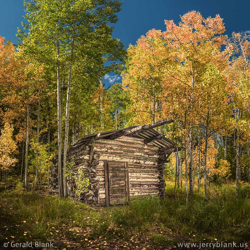
Log cabin near Ames, Colorado — Click / tap image to view full size
The old power station is the first thing one sees upon arriving in Ames, as well as a house where the plant supervisor lives. Clicking the link above will give you a bird’s-eye view of the power station, which has a blue roof.
The village lies within the Uncompahgre National Forest, and there is an unmarked access road just past the supervisor’s house, on the south side of Ames Road. This two-track access road is visible in the “satellite image” view, but is not shown in the regular view of Google Maps.
I had this all pretty much figured out before I arrived in Ames one day in September, but for good measure I had printed out the Google Earth image and had it in the car within easy reach. In the mountains, it can be tough to find one’s location with only a smartphone. A hiker’s GPS is a better bet, because it does not rely on cell signals. The user typically pre-loads maps into the unit before beginning a journey.
Barely a tenth of a mile uphill from the start of the two-track road, I was pleasantly surprised to see the old log cabin pictured here. The front of its roof is barely visible in the Google Earth image. I had come to Ames in search of the waterfalls on the Lake Fork, so stumbling upon the cabin was an unforeseen bonus.
The leaves filtered the sunlight around the cabin, lending a warm glow to everything in the scene. As you can see, the aspens were only beginning to change color, and had not dropped many of their leaves... but there were a few sprinkled around the trail near the cabin, just enough to brighten things up a bit.
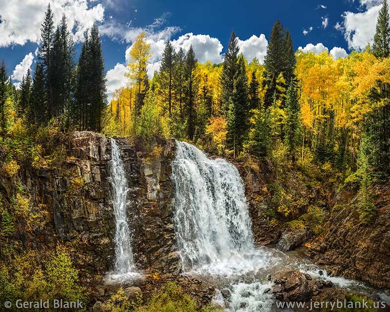
Since I did travel here in search of waterfalls, I soon took to the road again to find them. Finding the log cabin in the aspen grove was a lucky break. I was hoping for a second bit of luck, because the only information guiding me to the waterfall I sought were photos shared by other Colorado landscape photographers, who have titled their images “Mystic Falls”. Google Earth and the USGS map I consulted were of little help. The Google Earth aerial view does reveal two waterfalls on the Lake Fork of the San Miguel River, but they were unmarked until 2017—and vehicular access to the area was, well, “mystic”.
Long after returning home—in fact, just prior to writing this post—I searched online and found this helpful guide from SummitPost.org, which explains how to get to the two falls, named “Upper Ames Falls” and “Lower Ames Falls”. Finally, I knew for certain that the two other photographers had visited the lower falls. I found the upper falls, which is pictured below.
Upper Ames Falls on Lake Fork Creek, above Ames, Colorado —
Click / tap image to view full size
If you clicked the SummitPost link, you probably noticed the post includes a picture of the log cabin. As I mentioned above, the cabin is 0.1 miles up the two-track access road (which is described as a foot trail by SummitPost, because cars won’t get you up to the gorge through winter snow).
The upper falls are not hard to reach once one has driven past the log cabin. On the way up, I saw a fork in the road, and kept to the left since the USGS map did not show a right fork.
0.5 miles later, I found myself at a gate marked with “Private Property” and “No Vehicles Beyond This Point” signs. Those on foot can go around the gate; the private drive is an access point to a foot trail which leads to the Lizard Head Wilderness.
While investigating this, I could clearly hear the sound of the upper falls. There is no marked trail to guide visitors to the falls, but I only had to follow my ears west a short way to the Lake Fork gorge, picking my way carefully over a log-strewn stand of spruce trees. From the east side of the gorge, one can easily access the top of the falls, but I chose a vantage point a bit downstream, which gave me a nice encompassing view of the double waterfall and the colorful, sun-kissed aspen trees in the background. If you click the photo above and view it in full-screen mode, you can see points of yellow light strewn over the bare rock—thousands of gold and orange aspen leaves, which could be seen fluttering down the gorge whenever the breeze stirred.
I considered the possibility of shooting up from the bottom of the gorge, but it is steep, and I did not have a partner nor climbing ropes nearby. So I decided against it; it also seemed to me that a person at the bottom would see more dead trees and fewer of the nice-looking aspens behind the upper falls. If you read the SummitPost guide for ice climbers, you’ll notice that the writer climbed down the smaller waterfall; the large one on the right does not usually freeze solid, making it dangerous to attempt.
I never did search for the lower “Mystic Falls” during that trip. I may revisit Ames in the future to attempt that, but I will have to look more carefully for the trail described by the SummitPost guide!
Close to Ames, just off CO 145, I did find an excellent secluded spot from which I could view the Ophir Needles. Read more about that in this post.
↑ RETURN TO MAIN MENU AT TOP OF PAGE ↑
After a couple of autumn photo safaris to Colorado, I can recommend the San Juan Mountains, in the southwest corner of the state, as the largest area one can travel through and find glorious fall colors almost everywhere. Colorado’s autumn season typically starts in mid-September in the north, ending in the south in mid-October.
It would be nice if I could tell you the best week to visit the San Juan Mountains, and exactly where one can find the best colors on such and such a day. The reality, though, is after paying two visits to many of the same places, I found that every image captured during my recent 2014 trip was different from anything I had found during my first visit!
Telluride’s autumn scenery at its finest — Click / tap image to view full size
Some areas that had but little color before, such as Red Mountain Pass on US Hwy. 550, were practically on fire during the 2014 season, once touched by sunlight. And other places that I’d previously seen at their peak color were still green during my recent travels. Such is Nature. We cannot control it, so we roll with it.
How Colorado’s aspens behave once autumn sets in depends upon the year’s weather patterns... and what mood the trees are in, for all I know. Most aspen leaves turn into a beautiful shade of natural gold... glowing on slender branches for a week or so, and then falling gently to the ground in bright gold patches. In the middle of the season, some groves, change to a vivid orange color—and, here and there, a few patches of trees somehow go straight from green to a brilliant cherry red color. The red aspens may not be as showy as the hardwood trees of the Northeast, but they sure are a lovely sight when one spots them at the right time of the day.
During the 2014 season, I stayed in Telluride for several days; I had done some “virtual scouting” in Google Earth and various websites long before leaving home, and realized there are many miles of prime aspen forest that are easily accessed from US Hwy. 550, Colorado Hwy. 145, and various San Miguel County roads.
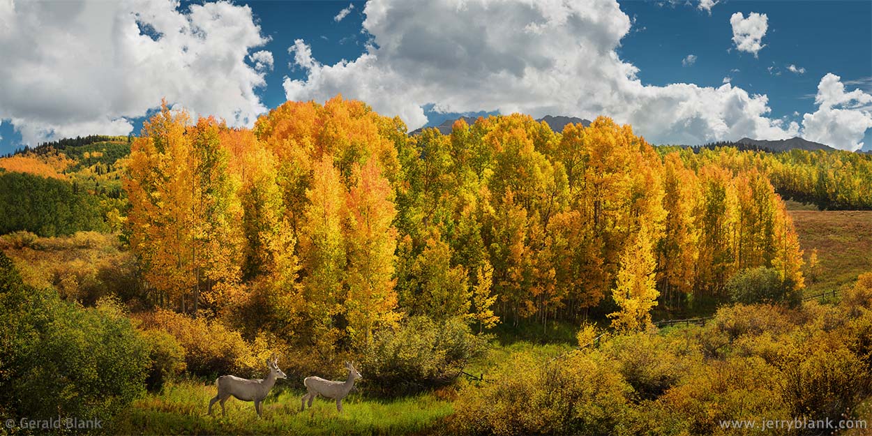
On one of those pleasant mornings, I left my hotel early and drove a short way south on CO 145, and a few miles west of Telluride Mountain Village and Bald Mountain. I didn’t travel very far that day, for the aspen groves between Telluride and Ophir were putting on a great show!
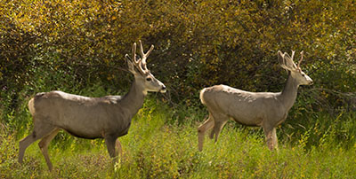
Deer near CO Hwy. 145 —
Click / tap image to view full size
During this trip, I didn’t rush frantically from one location to another as I’d done in the past. I decided I’d arrive at good places at the right time—not necessarily MY time—and in the end, I found my journey more relaxed and rewarding. This particular morning’s drive led me to a rare sight. Along the east side of CO 145, I discovered a single aspen grove with leaves of every color: Green, yellow, orange, red, and every hue in between! I set up my camera and tripod a few steps down from the shoulder of Hwy. 145, and became so focused on capturing the color that I failed to notice two young mule deer that had quietly walked into my field of view.
I was lucky, though: Another photographer had arrived on the scene, spotted the deer immediately, and was kind enough to draw my attention to them. I noticed few other deer this season, and so I am grateful to the nameless photographer, wherever he is, for the favor. The wildlife in the corner of the photo above is the perfect finishing touch to the scene.
I am more grateful, though, for the One who raised the mighty Rockies across this country of ours... the One who is also pleased to cover their meadows with summer wildflowers and autumn aspens for our enjoyment!
↑ RETURN TO MAIN MENU AT TOP OF PAGE ↑
Toward the end of my 2014 autumn adventure in Telluride, a cold front was forecast to move into the state, and the locals expected the surrounding peaks of the San Juan Mountains to be blanketed with snow by the morning of Sept. 29.
On the road from Telluride to Bridal Veil Falls. There are “Falling Rock” signs posted all over the USA—but if you see one in Colorado, you’d better take the warning seriously!
Late in the afternoon of the 28th, thundershowers rolled in from the west, bearing down quickly on the San Miguel River canyon and Telluride. But this was just a “shot across the bow”; the cold front was still far away, and rays of sunlight streamed eastward from a clear horizon.
In fact, after the initial cloudburst hit Telluride, the large gray blob of clouds over the canyon lost momentum, and began to break up instead of moving further to engulf Ajax Peak and Ingram Peak (pictured below).
But the gray blob was not yet ready to call it quits. A stiff and steady breeze picked up from the west, blowing large raindrops toward the mountains, and a huge double rainbow appeared just east of town, where there was plenty of sunlight to catch the falling rain.
I’ve done a bit of rainbow-chasing in my career, driving like an idiot on muddy gravel roads, and tearing my gaze from the sky just long enough to keep myself from driving into a ditch, or worse.

The double rainbow, shortly before sundown —
Click / tap image to view full size
That evening, with only minutes to work with, I knew there was only one way I could drive up the north wall of the box canyon in time to gain a clear view of the rainbows. That way is Tomboy Road, a very rough route which summer travelers use to visit the old Tomboy Mine site and to cross Imogene Pass to Ouray.
Such travelers, however, use high-clearance Jeeps—and I only had a rented SUV. Gritting my teeth, I began a short and stressful trip up Tomboy Road, carefully picking my way over very large rocks, and muttering mantras such as “He who hesitates is lost” and “Fortune favors the brave”. Sprinkled in between the mantras and prayers were a few curses, whenever I misjudged the terrain and heard a rock scrape the undercarriage of the SUV.
Luckily, I soon reached a bend in the road with a clear view, just past the east side of town. I had gained 1000 feet of elevation— well below the rim of the canyon, as can be seen in this photo, yet high enough to get the view I needed. I had only a few minutes for picture-taking; the rainbows were fading fast, as most rainbows do.
After my images had been captured, I collected my thoughts and was grateful that I’d encountered no oncoming traffic on the way up, because most of Tomboy Road is only one lane wide. The timing of this shot, like most of my rainbow photos, had been very close.
Having strugged to drive a thousand feet above Telluride, I decided to stick around for a while. When the conditions are right, Tomboy Road is a sweet vantage point for an evening time-lapse sequence, and for watching the town light up as the twilight fades over the San Miguel canyon. As my breathing and heart rate returned to normal, and the lights of Telluride began winking on, I saw that there would be no twilight this evening, for the cold front had finally arrived, and the horizon was now obscured by darkening clouds. But there were no clouds over my heart on that evening, for I have seen much that is wonderful in the San Juan Mountains during every one of my visits, and I take pleasure in sharing as many of those sights as I can!
Bridal Veil Falls may be the best-known waterfall within walking distance of Telluride, but by no means is it the only one. You can read about a couple of others in this post.
↑ RETURN TO MAIN MENU AT TOP OF PAGE ↑
If you happen to be traveling to Telluride, Colorado in the first half of October, it’s almost a sure bet that you will find great autumn colors on Wilson Mesa. Located west of Telluride Mountain Village in the Uncompahgre National Forest, its main feature is the San Miguel Range, consisting of Sunshine Mountain, Wilson Peak, and several other named and unnamed peaks.
The area is split roughly into northern and southern sections. Wilson Mesa lies primarily in a mix of private ranches and National Forest land to the south of CO Highway 145, and you can download a motor vehicle use map (MVUM) for the Mountain Division from the USFS website. As can be seen on the map, the Lizard Head Wilderness borders the National Forest farther south. The wilderness is where the larger peaks are located; vehicles are restricted to the marked Forest Service routes and trailheads.
Cabin in foreground, looking east to Sunshine Mountain —
Click / tap image to view full size
I first explored Wilson Mesa in Oct. 2008, via the road designated “60M” on the map (The brown road sign on CO 145 west of Telluride designates the route as “Silver Pick Road”). Due to lack of time, I only explored that route during my 2008 trip, but there are others. One does not have to hike into the wilderness to get great shots... but if you do enjoy hiking, there are several trailheads. I found plenty of great scenery visible right alongside 60M, which dead-ends within sight of Sunshine Mountain and Wilson Peak, east of Muddy Creek.
As evening approached, I had nearly reached the dead end, but just short of Muddy Creek I saw a picturesque view of Sunshine Mountain, framed by golden aspens, and could see an old cabin was just off the road to the south. The scene was pretty much handed to me on a platter; the light was perfect, and a recent snowstorm had white-capped the peaks, making them stand out nicely against the clear sky. I shot many photos that evening, but decided the the image above was the “keeper”.
Soon after taking the photo above, I crossed Muddy Creek and found the point where Road 60M dead-ends. From where the road crosses Muddy Creek, one can see a chain of beaver dams and ponds along the creek, and Wilson Peak looms large to the south. But by that time, both the ponds and Wilson Peak were in shadow. I did not realize at that time what excellent images could be had if I had chosen to stay overnight in Telluride and return to the same spot the following morning... so in my blissful ignorance, I drove east to Ouray to spend the last night of my excursion at the Thistledown campground.
Beaver ponds below Wilson Peak — Click / tap image to view full size
By the time I began planning my second visit to the Telluride area in 2014, I had more experience using Google Earth to determine when a particular mountainside will receive sunlight at pretty much any time—past, present, or future. Sometimes the photos posted on Google Earth are a helpful preview, and of course I had my 2008 images to use as a guide.
By the time I arrived in Telluride for my second autumn adventure in 2014, I knew that I could travel the same 60M route to Wilson Mesa in the early morning, and would capture completely different images. When I did return, for instance, I found the old cabin just where I’d left it six years earlier, but since it was backlit by the morning sun, I did not bother re-taking that photo. It was the same for Sunshine Mountain; the side that lights up brilliantly in an autumn afternoon is cast under shadow in the early morning.
On that morning, it was Wilson Peak’s turn to shine. It is the mountain which towers above Muddy Creek in the photo above. Although Sunshine Peak is photogenic, Wilson Peak is much closer to the 60M access road than Sunshine Mountain. It is tough to describe the awesome difference in perspective, but as can be seen in the picture, the mountain pretty much fills the frame. The chain of beaver ponds along Muddy Creek created some foreground interest.
The old cabin did not quite make it into the photo above; it’s located off the right side of this view. But I did capture some fine HD video footage of both the cabin and the mountain, which you can view in the “Colors of Colorado” clip on my YouTube channel.
If you take the advice in my opening paragraph and find yourself at a Mediterranean-looking ranch gate above the beaver ponds along Route 60M in October, you may be able to get permission to visit the beavers as I did, and receive more helpful tips!
You’ll note that snow adds nice contrast to this mountain, so it is good to arrive after the first snowfall, but before the leaves begin to drop from the aspen trees. That all depends upon the cooperation of Mother Nature, of course, but she does not get any complaints from me!
I also used Google Maps to do a virtual exploration of San Miguel County, in an attempt to find photogenic lakes. I was pleased to find a few with “drive up” access, including Woods Lake, just west of Wilson Peak in the San Miguel Range. Zooming in closer, I could see that the lake is surrounded by the Lizard Head Wilderness. Thankfully, at some time in the past, someone had the foresight to allow an easement for a one-mile access road and a campground at the lake, which you can see here on Google Maps.
The view across Woods Lake, on Wilson Mesa in Colorado —
Click / tap image to view full size
Late in September, while spending several days in Telluride, I traveled west on CO Highway 145 to Forest Service road 57P, which is signed “Fall Creek Road”, and turned south towards Woods Lake. Getting there was not a problem. The Forest Service roads on Wilson Mesa are maintained relatively well. The last mile of access road is steeper, with larger rocks, but it’s not too rough for most pickups and SUVs if one uses a lower gear and a little patience.
Upon arriving at the lake, I was pleased to find it was everything Google Maps had promised. There is space for small boat trailers to approach the edge of the lake, as well as several campsites. A network of trails surrounds the lake—so although one does not have to hike to it from the highway, those who enjoy hiking can take their pick of trails around the lake, some of which allow access to the Lizard Head Wilderness and the San Miguel Range.
There are a couple of peaks visible in the photo displayed here. The prominent triangular-shaped peak is a “no-name” peak at the end of the west ridge of Wilson. East of that peak, a bit of Wilson Peak can be seen peeking above the ridge on the left side of the photo. The scenery at Woods Lake is so good that I was surprised the place was not crowded with other explorers and campers. It seemed to me the perfect place to spend a night under a clear, star-filled Rocky Mountain sky.
I had a second camera in the back of my SUV, which I set up at the edge of the shoreline with a wide-angle lens, set to take time lapse photos at 30-second intervals. Later in 2015, I converted those images into a video clip, which made a great ending for the “Colors of Colorado” clip on my YouTube channel. Check it out!
↑ RETURN TO MAIN MENU AT TOP OF PAGE ↑
On the final day of my 2014 autumn trip to Colorado’s San Juan Mountains, I left Telluride early. A weather system had passed through the state the previous night, and although the morning skies were clear, it was looking to cloud up again quickly. My destination was Durango, but that morning I made a detour and revisited Wilson Mesa. I was glad I did so, because Wilson Peak had a fresh blanket of snow, as did all the other high peaks of the San Juans on that day.
It was late morning by the time I crossed Dallas Divide into Ouray County. I was almost surprised that the beautiful red-orange aspen grove on the west side, which I’d visited less than a week before, was nearly barren of leaves. Only a few reddish-brown leaves clung to the twigs. I say “almost” surprised because I know how quickly fall can turn into winter!
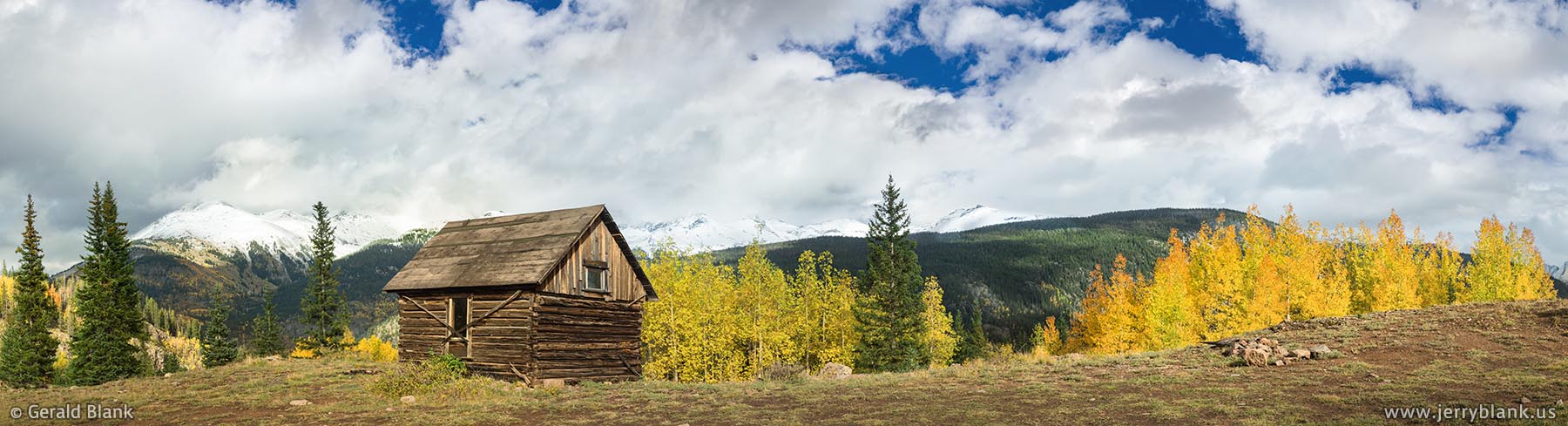
Log cabin and autumn foliage on a trail in the San Juan National Forest, south of Silverton
It was nearly overcast by that time, and there were few photo ops in the neighborhood. I could see plainly from the highway that the aspens of the Sneffels Range were still mostly green, and wouldn’t be ready for photographers for at least a week and a half. So I continued eastward to Ridgway, and turned south on US Highway 550 south toward Ouray.
After passing through Ouray, the highway steadily gains altitude up to Red Mountain Pass, which was another place I had visited only days before. Like Dallas Divide, the high-elevation aspens near Red Mountain Pass were done for the year.
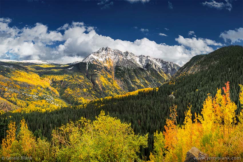
The Twilight Peaks, as seen from Coal Bank Pass in Colorado —
Click / tap image to view full size
Crossing south over the pass, I entered San Juan County and the San Juan National Forest. There wasn’t much to see till I approached Silverton. From the highway, I could see the Durango-Silverton Narrow Gauge Railroad train pulling into Silverton with its load of passengers.
After traveling a few miles south of Silverton, I caught a glance of a log cabin far off to my left, which is pictured above. The afternoon clouds were beginning to break up, so I waited patiently by the cabin until the clouds granted me a brief half-minute of sunlight in which to capture the image.
The shadows began to lengthen as the day drew to a close. Fortunately, the clouds were also continuing to dissipate, and by the time I reached Coal Bank Pass, I started seeing autumn aspen color again, as well as an outstanding view of the beautiful Twilight Peaks, pictured above right.
Indeed, as I drove past Coal Bank Pass and down Molas Pass into Durango, I could see more aspen groves whose fall colors were nearing their peak. I decided that I must come back to the San Juans in October and explore the San Juan National Forest between Durango and Silverton. It seems that autumn ends there somewhat later than it does in Ouray and Telluride, and much later than northern Colorado.
After parking next to my motel room in Durango, I was surprised to see the steam-powered locomotive of the Durango-Silverton railroad once again, chugging along just behind the motel. I was happy for its passengers, knowing that they had seen some of the finest autumn Colorado landscape that afternoon. It’s possible the passengers had the best photo ops in the area that day!